Analyzing Scout – The Transatlantic Autonomous Robot Performance
I am a big fan of Scout – The Autonomous Transatlantic Robot. This is a great project where a group of students got together to build and program an autonomous solar-powered boat from scratch, with the aim of having it cross the Atlantic from the US to Spain. You can track Scout's progress at the team's excellent tracking page.
Scout was supposed to travel to Spain along a series of waypoints almost forming the rhumb line from a point about 500 nm east of Chesapeake Bay to her port of destination in Spain. Due to a software bug, which was caused by a routine meant to prevent Scout from doubling back to waypoints she narrowly missed, Scout is now headed directly towards waypoint 44 in the Gulf of Cadiz, skipping waypoints 12–43.
Scout is trying to get there by following the great circle route from waypoint 11, about 35 nm south-west of Nantucket. This puts Scout quite a bit further to the north than originally planned. More importantly, though, this great circle puts Scout on a collision course with Portugal. The Scout team has expressed their hope that ocean currents will push her southwards enough to pass the south-western tip of Portugal.
I wanted to find out by how much Scout would have to move south from its great circle route for this to be possible. For this purpose I decided to monitor her progress in a different coordinate system. This is shown in the figure below.
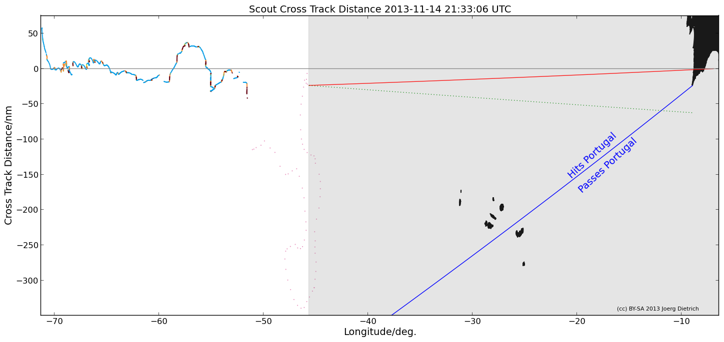
This figure shows by how much Scout moved away from the great circle connecting waypoints 11 and 44. This is called the "cross track error" or "cross track distance". Here it is plotted as a function of Scout's geographical longitude. The progress points are the same colors as on the team's tracking page. If Scout followed the great circle exactly, she would stay on the gray line with a cross track distance of zero. The red line is the great circle from Scout's current position to waypoint 44, i.e. the shortest path to her destination and the course she should sail. It is my understanding that Scout has no memory of the gray line and does not actively try to get back on it. In fact, this would be a clear disadvantage to her progress.
The black mass in the top right corner are Portugal and Spain, which are highly distorted in this coordinate system. We see that currently both the gray and the red great circle line intersect Portugal in the Algarve region. If Scout always tries to follow a great circle from her current location to the next waypoint, how far south would she have to drift to avoid running aground of the coast of Portugal?
The blue line answers this question. This is the great circle that connects waypoint 44 with the tip of Sagres Point. If Scout is south (to the right) of this line, her shortest path will lead her around the coast of Portugal. Any point north (to the left) of it keeps her on a collision course with the mostly rocky shore on Europe's western edge. We see that Scout has to move south quite a bit, more than she has deviated from her initial path yet. Should she accomplish that feat west of latitude 35W, there is the added danger of running into the Azores, which are also marked in this plot.
Whether this is a realistic prospect or not is not easy to answer. West of continental Europe the Gulf Stream bifurcates into the North Atlantic Drift and the Canary Current. If Scout is picked up by the latter she may have a good chance to make it to Spain. The strength and location of these currents has seasonal variations, adding an additional dependency on Scout's progress.
The figure will be automatically updated hourly with the latest real time data provided by the Scout team. Other analyses of the raw Scout data may follow, as my time permits. Country shapes were generated using the polygon files provided by Cloudmade. And finally a disclaimer: I am in no way affiliated with the Scout team. All the amazing work is theirs. I just play around with the data they provide on their webpage.
